
Fort San Pedro, Cebu: Entrance Fee, Hours and Four Centuries in Coral Stone
A 1565 triangle of coral stone that has been a fortress, a refuge, a barracks, and a school. ₱30 to walk through all of it.
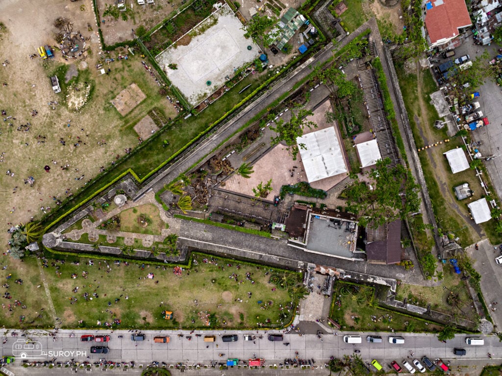
Fort San Pedro is the small triangular fort at Plaza Independencia, by Cebu’s port, and the oldest of its kind in the country: Legazpi broke ground on a wooden fort here in 1565, and the coral-stone walls standing today carry the date 1738 on the gate. Adult entry was ₱30 as of July 2026. The walls take twenty minutes to walk and the courtyard is a garden, so it works best as the first or last stop of a heritage walk rather than a destination on its own.
Go in the late afternoon, when the walls are out of the midday sun, and pair it with the free National Museum next door.
Plaza Independencia, Cebu City · 10.2922° N, 123.9053° E · Fee checked July 2026
Fort San Pedro entrance fee and hours
| What | Details |
|---|---|
| Adult entry | ₱30 as of July 2026. One April 2026 listing gives ₱50; the city has not published a rate card we could find. |
| Hours | Daytime. Listings give 8 AM to 7 PM daily; not confirmed for 2026. |
| Time to allow | 30 to 45 minutes, longer with the museum rooms |
| Run by | The Cebu City government, as a historical park since 2008 |
| Getting there | At Plaza Independencia beside the port. Jeepneys toward Pier 1 pass close by; see the Cebu jeepney guide. |
Bring small bills. Fees for city-run sites in Cebu change without much notice, and a ₱500 note at a ₱30 counter is nobody’s favorite transaction.
What you are looking at
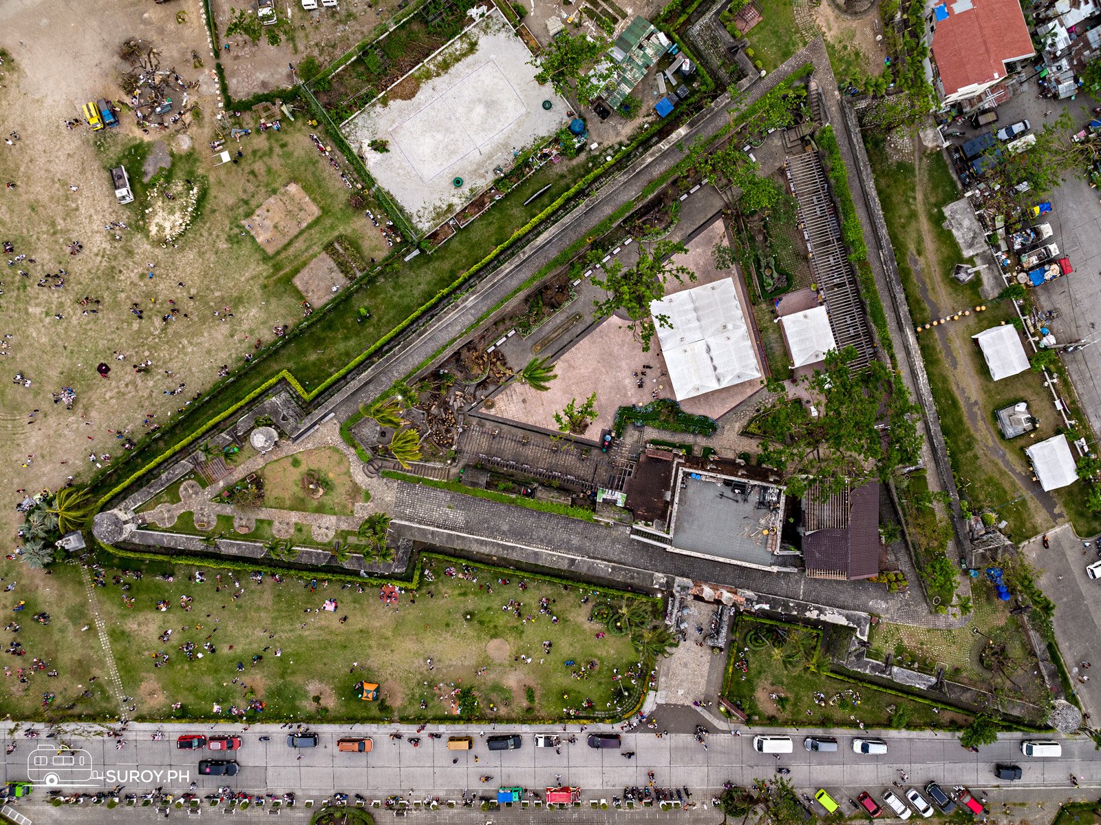
The fort is a triangle with a bastion at each corner: La Concepción to the southwest, Ignacio de Loyola to the southeast and San Miguel to the northeast. Two walls face the sea and one faces the land. The walls stand 6.1 m (20 ft) high and 2.4 m (8 ft) thick, the towers about 9.1 m (30 ft), and the whole circuit runs some 380 m. Fourteen cannons sit along the walls, most of them in their original positions.
Plaza Independencia · read the triangle
Three walls, three bastions, four centuries
Tap a number on the plan, then step through the fort’s many lives below.
San MiguelNortheast bastion
The corner bastion facing northeast. Each of the three corners carries a bastion, and the towers stand about 9.1 m (30 ft) above the ground.
Ignacio de LoyolaSoutheast bastion
The southeast corner, where the two seaward walls meet. The fort was built to watch the water and the raiders who came from it.
La ConcepciónSouthwest bastion
The southwest corner, at the end of the landward wall. Cannons still sit along the walls: fourteen in all, most of them in their original places.
The gateIn the landward wall
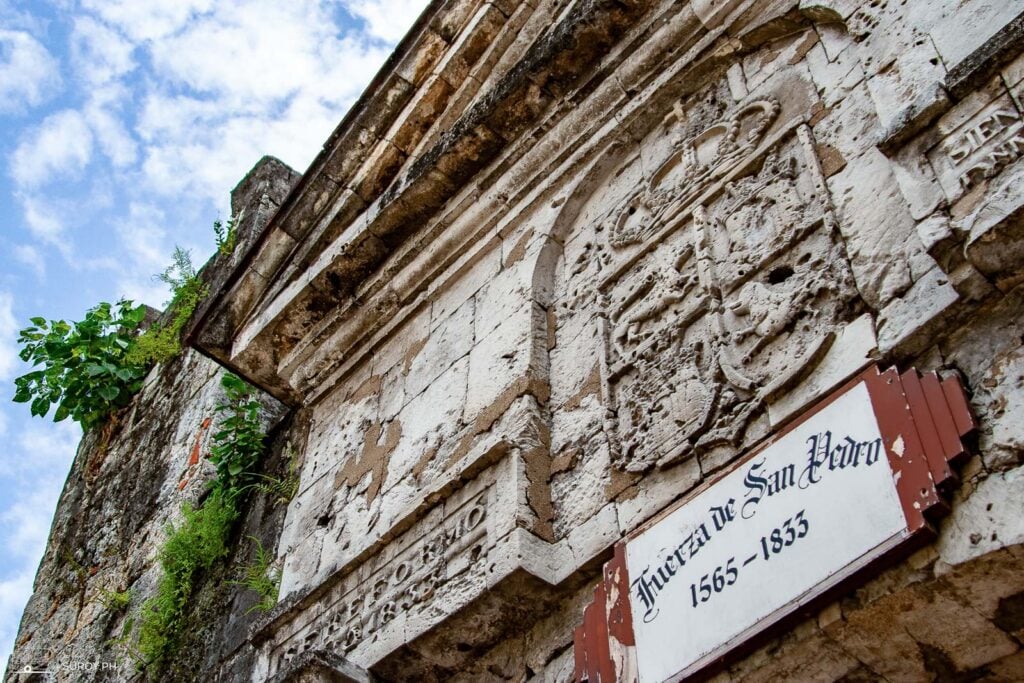
Visitors enter from the Plaza Independencia side. A plaque at the gate names the fort Fuerza de San Pedro.
The courtyardAbout 2,025 square meters inside
Once barracks and an armory, later a garden, a city zoo and an open-air theater. Today it is a lawn and garden with a museum in the old lieutenant’s quarters.
The walls6.1 m high, 2.4 m thick
Coral stone, about 20 feet high and 8 feet thick, running some 380 m around. Two walls face the sea, one faces the land.
The fort’s lives
1565Legazpi breaks ground on a wooden fort.
1738The date on the gate. Today’s stone structure is dated to that year.
1898Cebuano revolutionaries take the fort and hold it.
1900sPart of the American Warwick Barracks; a school from 1937 to 1941.
1942 to 1945Japanese residents shelter inside the walls; in the battle for Cebu it is an emergency hospital.
1946 to 1950An army camp.
1950sThe Cebu Garden Club plants the courtyard; from 1957, a city zoo.
About 1968Restoration with coral stone hauled from Cebu’s coast; the zoo moves out.
2008Made a historical park under the Cebu City government.
Dimensions and dates from the fort’s published history. Plan is schematic.
Fort San Pedro history
The fort began as Legazpi’s wooden stockade in 1565, the nucleus of the first Spanish settlement in the Philippines, and is usually said to take its name from his flagship, the San Pedro. Stone came later. The construction dates of the early stone fort are uncertain, but the gate carries 1738, and the present structure is dated to that year.
Then it kept changing jobs. Cebuano revolutionaries took it in 1898. The Americans folded it into the Warwick Barracks and, from 1937 to 1941, used it as a school. During the Second World War it sheltered Japanese residents and then served as an emergency hospital in the fight for Cebu. After the war it was an army camp, then a garden kept by the Cebu Garden Club, then, from 1957, a city zoo. Restoration started around 1968 with coral stone hauled from Cebu’s coastal towns, and in 2008 the city made it a historical park. It is a National Historical Landmark.
What to do inside
- Walk the walls. The ramparts are the point: views over the courtyard, the plaza and the port side.
- Find the cannons. Fourteen of them, most where they were placed.
- The museum rooms. Housed in the old lieutenant’s quarters, with documents, artifacts and photographs of the fort’s many uses.
- The courtyard. A lawn and garden now, and occasionally an open-air stage.


The drawbacks: it is small, and the museum is modest. Anyone expecting Intramuros will be done in half an hour. Midday is hot on the walls with little shade, and signage is thin, so the plan on this page does some of the work a guide would.
Plaza Independencia, right outside
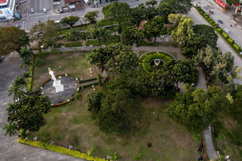
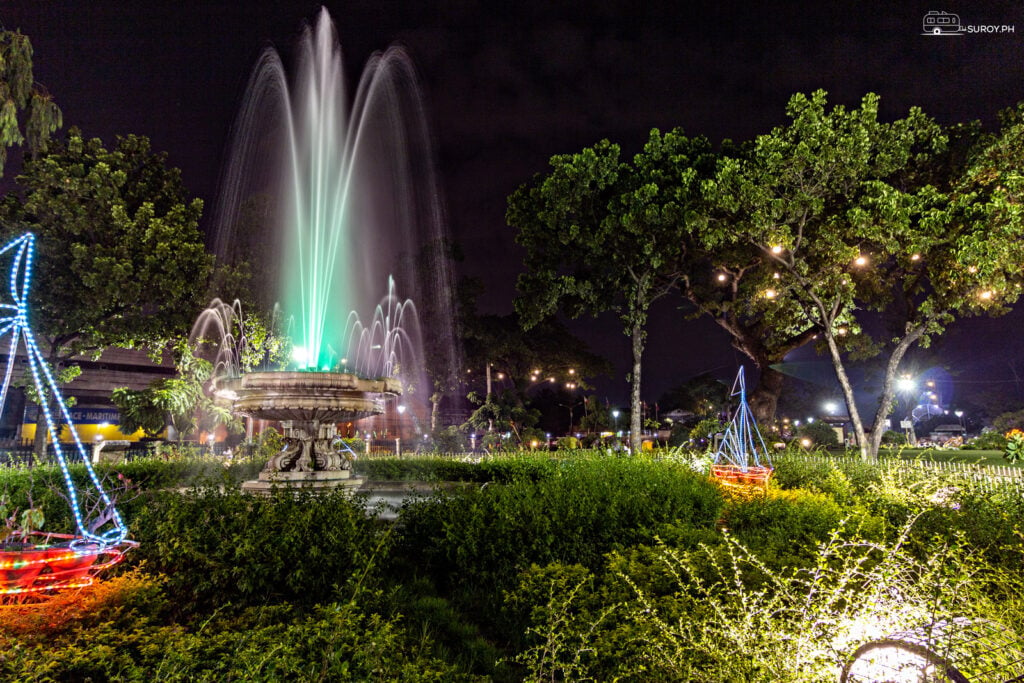
The fort sits at the corner of Plaza Independencia, the old Plaza de Armas of the 1699 map. The obelisk at its center honors Legazpi, and the fountain lights up after dark. When Typhoon Odette crossed Cebu in December 2021 it stripped the plaza’s trees bare, which the aerial below shows.

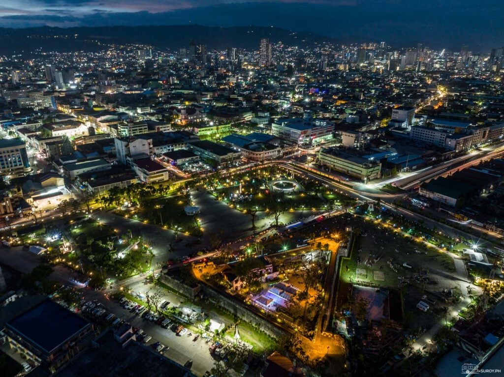
The Cebu heritage walk
Fort San Pedro is stop two of nine on a walk that runs from the port to the Parian houses and Colon Street, about half an hour of walking in all.
Old Cebu on foot · nine stops
The heritage walk, port to Parian
Tap a pin or a stop for fees, hours and the walk to the next one. About 30 minutes of walking in all, plus the time inside.
Stop 1 of 9
National Museum, CebuMalacañang sa Sugbo, the 1910 Customs HouseGold, galleons, a whale shark and the Battle of Mactan mural, in the old Customs House by the port.
FeeFree
HoursDaily from 9 AM, Mondays included; closing posted as 5 or 6 PM (checked October 2026)
Next: Fort San Pedro, about 2 min on foot
Read the guideStop 2 of 9
Fort San PedroThe triangular fort, 1565 and 1738You are on this page
The smallest and oldest of the Spanish forts. Walk the walls, then the garden courtyard.
FeeAdults ₱30 as of July 2026; one 2026 listing says ₱50
HoursDaytime; older listings say 8 AM to 7 PM
Next: Magellan’s Cross, about 8 min on foot
Stop 3 of 9
Magellan’s CrossThe kiosk outside the basilica gateThe octagonal kiosk on Magallanes Street holds the cross that marks the 1521 baptisms.
FeeFree
HoursOpen through the day
Next: Basilica del Santo Niño, about 2 min on foot
Read the guideStop 4 of 9
Basilica del Santo NiñoFounded 1565, stone church 1735 to 1740Home of the Santo Niño. Sleeves and covered legs at the gate; Friday is the busiest day.
FeeFree
HoursGates 4 AM to 9 PM daily (checked October 2026)
Next: Cebu Metropolitan Cathedral, about 3 min on foot
Read the guideStop 5 of 9
Cebu Metropolitan CathedralSeat of the Archdiocese of CebuRebuilt after the 1944 bombing left only the facade, walls and belfry standing.
FeeFree
HoursNot verified
Next: Heritage of Cebu Monument, about 6 min on foot
Stop 6 of 9
Heritage of Cebu MonumentEduardo Castrillo, 1997 to 2000Concrete, bronze, brass and steel: Cebu’s history in one tableau on the old Plaza Parian.
FeeFree
HoursOutdoor, always visible
Next: Yap-Sandiego Ancestral House, under 2 min on foot
Read the guideStop 7 of 9
Yap-Sandiego Ancestral HouseA Chinese merchant’s house, late 1600sA private family house opened to visitors, one of the oldest homes in the country.
FeeListed at ₱50 to ₱100; confirm at the door
HoursListed as daily from about 9 AM, not verified
Next: Casa Gorordo Museum, about 2 min on foot
Stop 8 of 9
Casa Gorordo MuseumThe 1850s house of Cebu’s first Filipino bishopA bahay na bato run as a museum since 1983. Closed Mondays.
FeeListed at ₱100 to ₱150 for adults in 2025; confirm at the door
HoursTuesday to Sunday from 9 AM; closed Mondays
Next: Colon Street, about 6 min on foot
Read the guideStop 9 of 9
Colon Street1.17 km of downtown, named for ColumbusBudget shopping, old cinema buildings and the most argued-about “oldest street” claim in the country.
FeeFree
HoursShops open from mid-morning
End of the walk. Colon runs west for about 15 minutes end to end.
Read the guideWalking times are estimates from map distance at an easy pace. Fees and hours as dated; listings that could not be confirmed are marked.
The fort is where the Spanish city began, a few hundred meters from the water. The Cebu Coordinates Tee puts the island down as the numbers that find it.
Suroy Wear · Island Series

10.3157° N, 123.8854° E.
The island where the walk begins, printed as the numbers that find it. Made in Cebu. ₱999.
Wear the story
To see Fort San Pedro as part of a half day on foot through the old city, follow the Cebu heritage walking tour.
Frequently asked questions
How much is the Fort San Pedro entrance fee?
₱30 for adults as of July 2026. One April 2026 listing gives ₱50, and no official rate card is published, so bring small bills.
What are Fort San Pedro’s opening hours?
Listings give 8 AM to 7 PM daily. These could not be confirmed for 2026; plan a daytime visit.
Is Fort San Pedro the oldest fort in the Philippines?
It is the oldest triangular bastion fort in the country. Legazpi broke ground on a wooden fort here in 1565, and the present stone structure dates to 1738.
What are the three bastions called?
La Concepción (southwest), Ignacio de Loyola (southeast) and San Miguel (northeast).
What is near Fort San Pedro?
The National Museum of the Philippines, Cebu, two minutes away; Magellan’s Cross and the Basilica del Santo Niño, under ten minutes on foot.