Osmeña Peak: The 30-Minute Climb, the ₱50 Fee, and Whether It Is Really Cebu’s Highest
Osmeña Peak is the jagged summit above Mantalongon in Dalaguete, commonly listed at 1,013 meters and signposted as the highest point in Cebu, and it is the easiest big view on the island: about 20 to 30 minutes on foot from the jump-off. Bring ₱50 for the registration fee, or ₱150 if a guide is required on the day, and get there before 6 AM if you want the hills before the clouds roll in.

Osmeña Peak · Dalaguete
Before you go up
Tap a tab.
1,013 m, as listed
The height
Osmeña Peak is commonly listed at 1,013 meters and signposted as Cebu’s highest point, though no source cites a survey. A peak-bagging site page published in March 2026 lists Marciano Peak, about 2 km north on the same ridge, at 1,073 meters.
₱50, or ₱150 with a guide
The fee
₱50 a person at the registration hut by the car park, per two 2025 and 2026 guides. A February 2026 visitor paid ₱150 including a guide. Whether a guide is now required was not confirmed; carry ₱150 in small bills.
20 to 30 minutes
The climb
From the jump-off it is about 20 to 30 minutes on a stone path and a short steep scramble to the summit. The jagged hills around it are the view, not the summit marker.
Bus, then habal-habal
Getting there
Bus from the Cebu South Bus Terminal to Dalaguete, then a habal-habal up to Mantalongon and the jump-off. Every published fare predates the 28 September 2026 provincial fare increase, so budget above them.
Dalaguete side, Badian summit
Which town
Access, parking and registration are on the Dalaguete side at Mantalongon. A 2025 report places the summit itself in Barangay Patong, Badian; the province ordered the two towns to co-manage it in 2018.
Checked 30 October 2026.
Is it really the highest point in Cebu?
Probably not, though it is the one with the sign. Suroy.ph found no survey behind its listed 1,013 meters. A peak-bagging site page published in March 2026 lists Marciano Peak, about 2 km north on the same ridge in the Mount Labalasan range, at 1,073 meters and calls it the true high point. No official survey figure was found for Marciano either. Mount Lanaya in Alegria, sometimes named as a rival, is listed at about 720 meters and is not in the running.
Treat 1,013 meters as the posted height; the view is the same either way.

The fee and the registration
Two guides from July 2025 and May 2026 put the fee at ₱50 a person, paid at a registration hut near the car park at the jump-off. A visitor in February 2026 paid ₱150 including a guide, with parking by donation and camping at the top ₱50. Whether a guide is now required was not confirmed by a second source. Carry ₱150 in small bills and let the hut tell you.
| Item | Amount | Source |
|---|---|---|
| Registration fee | ₱50 a person | 2025; cebu.tips May 2026 |
| Fee with guide | ₱150 | February 2026 |
| Camping at the top | ₱50 | February 2026 |
| Parking | By donation | February 2026 |
The climb
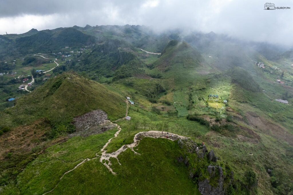
From the jump-off a stone path climbs past a few huts, then a short steep scramble reaches the summit: about 20 to 30 minutes for most people. The view is the field of steep, cone-shaped hills to the south and west, often compared to the Chocolate Hills, with the sea on the horizon on a clear morning.
Clouds come in fast. Suroy.ph’s frames from the summit show both faces of it: the hills sharp under high cloud, and the same field lost in fog. Start before 6 AM for the best chance of a clear view; the dry months from March to May are the best bet, and August and September bring mud and fog.


Getting there
By public transport, take a bus from the Cebu South Bus Terminal to Dalaguete, then a habal-habal up the mountain road to Mantalongon and on to the jump-off. Published fares for the bus range from about ₱110 to ₱200 and for the habal-habal about ₱100 to ₱250 from Dalaguete to Mantalongon plus about ₱30 to ₱100 on to the jump-off, but every one of them predates the provincial fare increase of 28 September 2026. Budget above them and agree the habal-habal fare before you get on.
Access, parking and registration are all on the Dalaguete side. A 2025 report places the summit itself in Barangay Patong, Badian, and in 2018 the province ordered the two towns to co-manage the peak.
Camping and the traverse
Campers pitch on the grass near the summit; bring a tent pegged for wind and expect a damp night. The classic follow-up is the descent west to Kawasan Falls in Badian, about four to five hours on foot; see the Osmeña Peak to Kawasan hike for the route, and Kawasan Falls for the falls at the end.


Somewhere in those hills is a set of coordinates people drive four hours for. The Cebu Coordinates tee carries the island’s.
Suroy Wear · Island Series

Cebu Coordinates.
For the island seen from its highest signposted point. Made in the Philippines. ₱999.
Wear the story
Frequently asked questions
How high is Osmeña Peak?
It is commonly listed at 1,013 meters. A 2026 peak-bagging site lists Marciano Peak, about 2 km north on the same ridge, at 1,073 meters.
How much is the entrance fee at Osmeña Peak?
₱50 a person per 2025 and 2026 guides; one February 2026 visitor paid ₱150 including a guide.
How long is the hike to Osmeña Peak?
About 20 to 30 minutes from the jump-off.
How do you get to Osmeña Peak from Cebu City?
Bus from the Cebu South Bus Terminal to Dalaguete, then a habal-habal to Mantalongon and the jump-off.
Is Osmeña Peak in Dalaguete or Badian?
Access is from Mantalongon in Dalaguete; a 2025 report places the summit in Barangay Patong, Badian. The two towns were ordered to co-manage it in 2018.
Photographs by Suroy.ph, filed July 2024. Checked 30 October 2026.